|
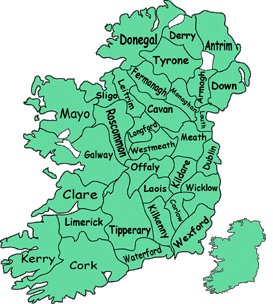
IRISH MAP - COUNTIES
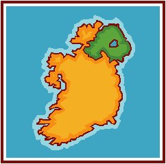
The island of Ireland is divided into two countries; the
southern and northwestern regions constitute the Republic of
Ireland, an independent, democratic country. The northeast
is Northern Ireland and presently is a part of the United
Kingdom.
Throughout the entire island of Ireland are thousands of
lakes and rivers that are natural wonders. In addition,
Ireland's ancient past makes it an archeological paradise,
with many sites dating back thousands of years.
Historically, Ireland is divided into four ancient
provinces, Leinster, Munster, Connacht and Ulster.
There are thirty-two counties within those provinces
which have existed since the late 16rh century.
Twenty-six of the counties are in the Irish Republic and
six are in Northern Ireland.
| PROVINCE |
COUNTY |
| Connacht (5) |
Galway, Leitrim, Mayo, Roscommon and Sligo |
| Leinster (12) |
Carlow, Dublin, Kildare, Kilkenny, Longford,
Laois, Louth, Meath, Offaly, Wexford, Westmeath and
Wicklow. |
| Munster (6) |
Claire, Cork, Kerry, Tipperary, Waterford |
Ulster
(9) |
Antrim, Armagh, Cavan, Derry, Donegal, Down,
Fermanagh, Monaghan and Tyrone. |
|
|